


 English
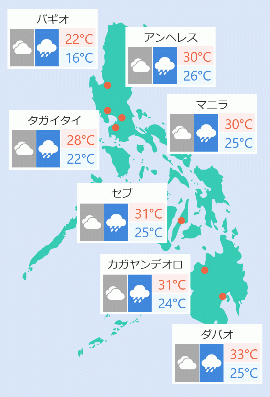
The eyewall of Typhoon ''Karding'' is affecting Polilio Islands and the Philippine Atmospheric, Geophysical and Astronomical Services Administration (Pagasa) expects'' landfall in the vicinity of the northern portion of Quezon or southern part of Aurora'' Sunday night.
More areas have been placed under Tropical Cyclone Wind Signal Number Five, while ''heavy to intense with at times torrential rains over Metro Manila, Zambales, Bataan, Tarlac, Pampanga, Nueva Ecija, Bulacan, Aurora, Rizal, and the northern portion of Quezon including Polillo Islands'' are forecast.
The northern part of Metro Manila is still under Tropical Cyclone Warning Signal Number Four. These are Marikina, Caloocan, Malabon, Navotas, Valenzuela, and Quezon City.
The other areas of Metro Manila are under Tropical Cyclone Warning Signal Number Three, Pagasa added.
''Karding'', which has winds of up to 195 kilometers per hour and gusts of up to 240 kilometers per hour, is moving westward at 20 kilometers per hour.
Areas under Tropical Cyclone Warning Signal Number Five are Polillo Islands, the extreme northern portion of Quezon (the northern and central portions of General Nakar, the northeastern portion of Infanta), the extreme southern portion of Aurora (Dingalan), the extreme southern portion of Nueva Ecija (General Tinio, City of Gapan, Peñaranda, San Isidro, Cabiao), Pampanga (Arayat, Candaba, Santa Ana, San Luis), the eastern and central portions of Bulacan (San Rafael, Angat, Norzagaray, Doña Remedios Trinidad, San Ildefonso, San Miguel), and the extreme northern portion of Rizal (Rodriguez), the eastern portion of Pampanga (Candaba, Arayat).
''Karding' will traverse the landmass of Central Luzon and emerge over the West Philippine Sea via the coastal waters of Zambales or Pangasinan,'' said Pagasa. It is expected to lose strength once it makes landfall and crosses Central Luzon, said weather forecaster Cris Perez over dzBB.
Along with the northern part of Metro Manila, other places under Tropical Cyclone Warning Signal Number Four are Calaguas Islands, the central and southern portion of Nueva Ecija (Cuyapo, Nampicuan, Guimba, Licab, Zaragoza, San Antonio, San Leonardo, Jaen, Santa Rosa, Palayan City, Gabaldon, Laur, Cabanatuan City, Aliaga, Quezon, Santo Domingo, Talavera, Llanera, General Mamerto Natividad, Rizal, Bongabon, Talugtug, Science City of Muñoz), Tarlac, the rest of Pampanga, the rest of Bulacan, Zambales, the northern portion of Bataan (Dinalupihan, Hermosa, Morong, Orani, Samal, Abucay), the southern portion of Pangasinan (Bautista, Alcala, Bayambang, Mangatarem, Urbiztondo, Aguilar, Bugallon, Infanta, Dasol, Burgos, Mabini, Labrador), and the extreme northern portion of Laguna (Famy, Siniloan, Santa Maria, Pangil).
Also under Tropical Cyclone Warning Signal Number Three are the central portion of Aurora (Dipaculao), the southeastern portion of Nueva Vizcaya (Alfonso Castaneda, Dupax del Sur, Dupax del Norte), the rest of Nueva Ecija, the rest of Bataan, the rest of Pangasinan, the rest of Rizal, the northern and central portions of Laguna (Mabitac, Pakil, Paete, Kalayaan, Lumban, Cavinti, Pagsanjan, Luisiana, Majayjay, Magdalena, Santa Cruz, Pila, Liliw, NM