


 English
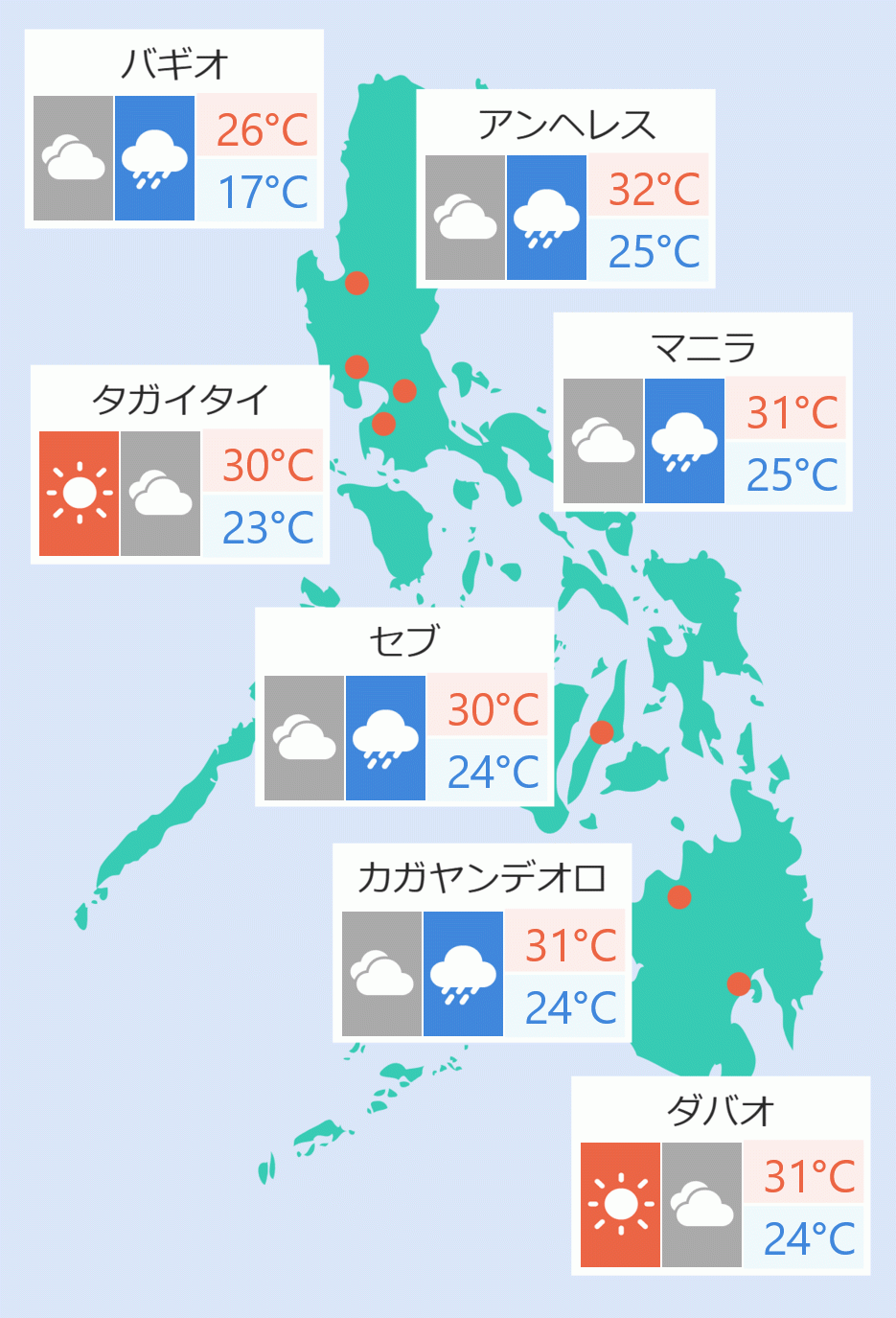
Tropical storm ''Ursula'' has slightly intensified as it heads west northwest towards Eastern Visayas, the Philippine Atmospheric, Geophysical and Astronomical Services Administration (Pagasa) said Monday.
According to the weather bureau's 5 pm bulletin, ''Ursula'' was last located at 670 kilometers east of Surigao City.
From maximum winds of 65 kilometers per hour and gusts of 80 kilometer per hour, Ursula is carrying winds and gusts of up to 75 kilometers per hour and 90 kilometers per hour, respectively.
Pagasa said ''Ursula'' is expected to gradually intensify into a severe tropical storm before making landfall over Eastern Visayas on Tuesday morning or evening.
The weather bureau raised tropical cyclone wind signal number two over Guiuan, Eastern Samar.
Signal number one was also raised over the following:
Luzon: Southern portion of Quezon including Buenavista, Calauag, Catanauan ,General Luna, Guinayangan, Lopez, Macalelon, Mulanay, San Andres, San Francisco, San Narciso and Tagkawayan; Camarines Sur; Camarines Norte; Catanduanes; Albay; Marinduque; Romblon; Sorsogon; and Masbate including Ticao and Burias Islands.
Visayas: Rest of Eastern Samar; Northern Samar; Samar; Biliran; Leyte; Southern Leyte; Northern Cebu (Carmen, Asturias, Tuburan, Catmon, Sogod, Borbon, Tabuelan, Tabogon, San Remigio, Bogo, Medellin, Daanbantayan, Bantayan Islands, Camotes Islands); Central Cebu (Aloguinsan, Carcar, Pinamungahan, San Fernando, Naga, Toledo, Minglanila, Balamban, Talisay, Cebu City, Cordova, Lapu-Lapu, Mandaue, Consolacion, Liloan, Compostela, Danao ); northeastern Bohol (Inabanga, Danao, Dagohoy, Pilar, Guindulman, Anda, Candijay, Alicia, Buenavista, Jetafe, Talibon, Trinidad, Bien Unido, San Miguel, Ubay, Mabini, Pres. Carlos P. Garcia); Aklan; Antique; Capiz; Iloilo; Guimaras; northern Negros Occidental (Bacolod, Bago, Cadiz, Calatrava, Enrique B. Magalona, Escalante, La Carlota, La Castellana, Manapla, Moises Padilla, Binalbagan, Hinigaran, Isabela, Murcia, Pontevedra, Pulupandan, Sagay, Salvador Benedicto, San Carlos, San Enrique, Silay, Talisay, Toboso, Valladolid, Victorias); and northern Negros Oriental (Canlaon, Guihulngan, Jimalaud, La Libertad, Vallehermoso).
Mindanao: Dinagat Islands and Surigao del Norte including Siargao Islands.
"Between Tuesday and Wednesday morning, moderate to heavy rains over Dinagat Islands, Siargao and Bucas Grande Islands, Eastern Visayas, Romblon, Aklan, Antique, Capiz, Iloilo, and the northern portions of Cebu and Negros Occidental. Light to moderate with intermittent heavy rains over Bicol Region, Quezon, Marinduque and the rest of Visayas and Surigao del Norte," said Pagasa.
"Between Wednesday morning and late evening: Moderate to heavy rains over Mindoro Provinces, Marinduque, Romblon, Aklan, Antique, Capiz, and northern portion of Palawan inlcuding Cuyo and Calamian Islands. Light to moderate with intermittent heavy rains over Calabarzon," it added.
Winds from ''Ursula'' may begin to affect the areas under Tropical Cyclone Wind Signal Number Two Wednesday afternoon.
Strong winds may affect northeastern Mindanao, the rest of Eastern Visayas, southern portion of Bicol Region, some portions of Central Visayas, and some portions of Western Visayas.
Due to rough to very rough seas, the weather bureau announced sea travel is risky over areas under tropical cyclone wind signals and over the northern and eastern seaboards of Bicol region, the eastern seaboards of Eastern Visayas and Caraga Region beginning Monday night or Tuesday morning. Cristina Eloisa Baclig/DMS