

 English
The National Risk Reduction and Management Council (NDRRMC) warned the public on the possible effect of a strong typhoon that may enter the Philippine Area of Responsibility this week.
NDRRMC said, according to state weather forecasters, there is the possibility that Typhoon Kammuri which will be called as Typhoon ''Tisoy'' to intensify into a "super typhoon."
“Kammuri has intensified into a typhoon and may enter the Philippine Area of Responsibility as Typhoon ''Tisoy'' on Saturday (30 November) or Sunday (1 December)," said NDRRMC.
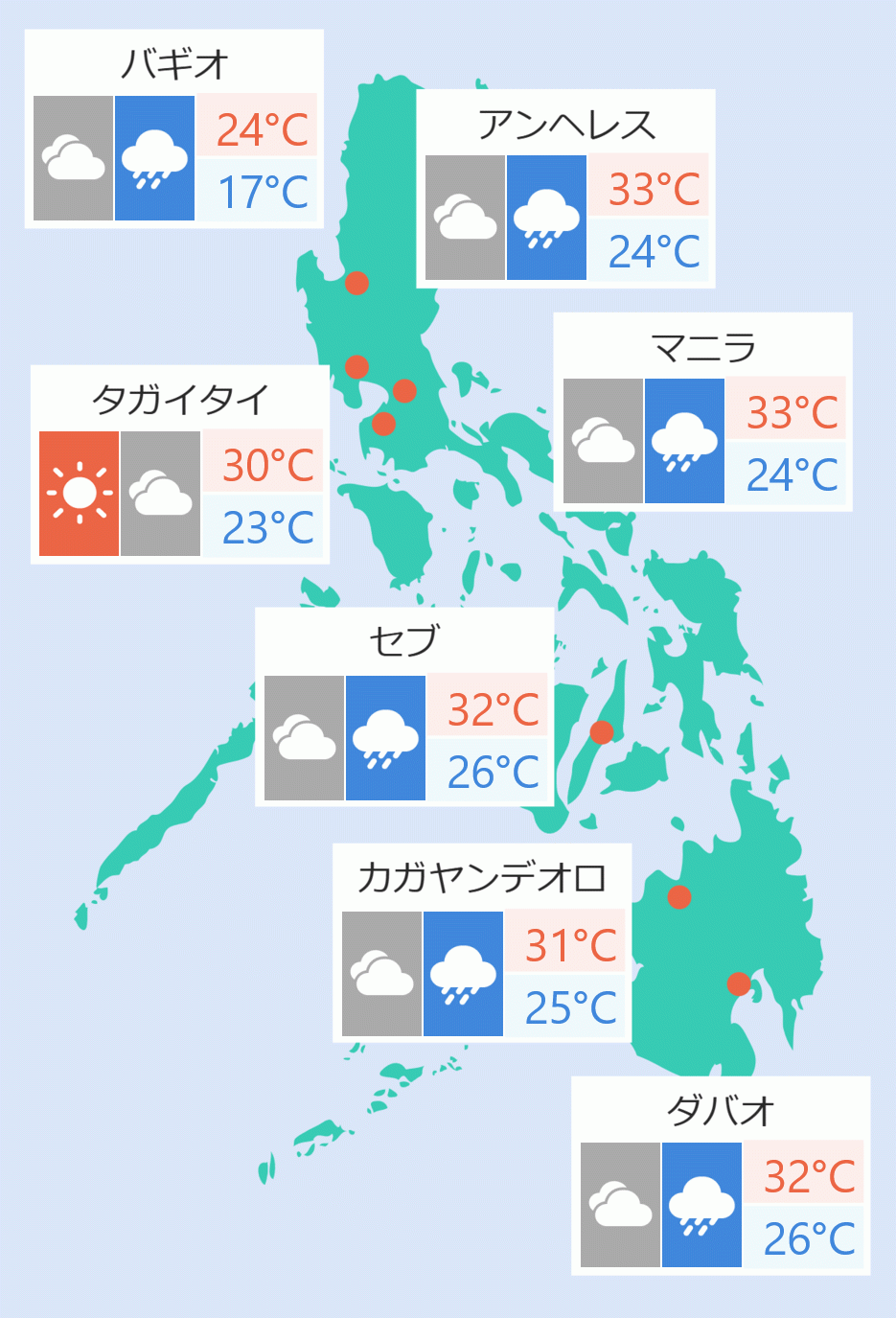
As of Friday afternoon, Kammuri remained almost stationary some 1,455 kilometers east of Southern Luzon. It has winds of up to 140 kph and gusts of 170 kph.
''Tisoy'' is projected to strengthen further as it approaches, and may bring continuous heavy rains over Luzon and Eastern Visayas which could cause flooding and landslides, it added.
Based on weather forecast, ''Tisoy'' may reach peak intensity in four to five days.
"With dates December 3 and 4 projected as critical, the Philippine Atmospheric, Geophysical and Astronomical Services Administration (Pagasa) warned of the likelihood of maximum sustained winds reaching 185 km/h and the possible raising of at least Tropical Cyclone Wind Signal No. 3 on these dates," said NDRRMC.
It said "TCWS No. 3 can bring heavy damage to high-risk structures, unroof houses made of medium strength materials, damage shrubbery, break or uproot large trees, and topple electric posts. Storm surge is also possible in coastal areas."
NDRRMC said "Kammuri follows a similar track to previous Typhoons Reming in 2006 and Glenda in 2014, which cuts across Luzon".
It also recalled that ''Reming'' resulted in the death of 734 individuals, while ''Glenda'' caused the death of 106 people and damaged properties amounting to P38.6 billion.
Areas of Central Luzon, Metro Manila, Bicol Region, Calabarzon, Mindoro, Marinduque, Romblon and Samar Island maybe be affected by continuous heavy rains from Tuesday to Wednesday morning.
NDRRMC said during the same period frequent heavy rains are projected over Northern Luzon due to the typhoon’s interaction with the tail-end of a cold front and can induce flooding or landslides.
"Flooding may occur in low-lying areas and landslide in mountainous areas in Regions II ( Cagayan Valley), III ( Central Luzon), V (Bicol) , Calabarzon, and Mimaropa. Magat Dam may release water from its shed and cause flooding in certain areas depending on the amount of rainfall," it added.
The NDRRMC also advised the residents in the identified areas to "monitor tension cracks, fractured rocks and sediments, sliding slope and active slides, and soil overburden which are common signs of impending landslides".
"Residents in low-lying areas or near riverbanks who experience prolonged rainfall should exercise caution and monitor the level of river water considering that heavy rainfall may cause riverbank erosion, shift of river flow direction, debris flows and artificial damming," it stated.
As part of its preparation, the NDRRMC placed its operation center under blue alert status to monitor the effects and response actions.
"Emergency Operations Centers have also been activated in Regions I ( Ilocos), II ( Cagayan Valley), III ( Central Luzon), CAR ( Cordillera Administrative Region), and V ( Bicol), '' it said.
OCD Administrator and NDRRMC Executive Director Ricardo Jalad also directed all the member agencies to scale up preparations for the possible impacts of the typhoon.
“We cannot leave this storm to chance. Let us strengthen all preparedness efforts at the national, regional, and local government levels," he said.
"We also advise affected residents to expect possible pre-emptive evacuations and take precautionary measures. Let us learn from our history of past typhoons and become more cooperative and prepared,” Jalad added.